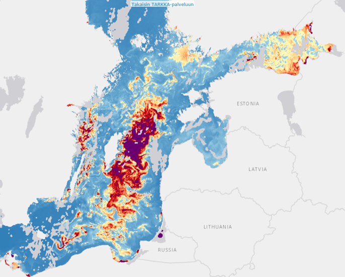
Chlorophyll-α
This dataset is not yet available in the current version of Tarkka.
Chlorophyll-a (chl-a) concentrations are currently interpreted as statistics consisting of observations of cloudless days. The material covers the waters around Finland and the water bodies of the coast and lakes. An annual map illustrating the average concentration (reference to summaries) is compiled from the interpretations. The data is visible in the Tarkka service at the reference station sites; chl-a interpretation is performed using a model based on the Case2extreme neural network (C2X, Brockmann et al. 2016). Cloudy areas are pruned using the IDEPIX algorithm, which is openly available through SNAP. The cloud detection result of the IDEPIX model is supplemented by the cloud shadow area detection method developed in SYKE. The development of daily chl-a material is based on observations from Copernicus instruments is underway and examples will be available during 2020.
For the years 2002-2011, the Tarkka service contains daily chl-a data based on the observations of the ENVISAT satellite MERIS instrument, which covers the entire Baltic Sea region. The interpretation is based on a bio-optical neural network algorithm, FUB (Schroeder et al. 2007a; 2007b). The accuracy of the data has been assessed for the sea areas around Finland and especially for the Finnish coast. The chl-a content of the water can be determined reliably based on satellite observations, the estimate deviates from the station observations by an average of 0.6 μg l-1, which is close to the analytical accuracy of laboratory analyzes of water samples. In dynamic estuaries, where the amount of solids and humus from the catchment area is occasionally high, the determination accuracy of chl-a content can be further improved (Attila et al. 2018, Attila et al. 2019). For the high seas of the Baltic Sea, chl-a data have been utilized in HELCOM’s eutrophication status assessments (HELCOM, 2015; HELCOM, 2018). During the period of the MERIS instrument, cloud detection was performed using the Cloudmask algorithm of the BEAM program, which was supplemented from the edges of the cloud areas and, if necessary, manually.
Validation results
The chl-a concentrations interpreted from the satellite observations correspond well to the observations made at the stations in the areas of coastal and lake water bodies on an annual basis, (r2 = 0.49 (R = 0.7) RMSE = 5.4 µg l-1 (60.2%), MAE = 3.75 µg l-1 , N = 1484). Site-specific accuracy is also good for same-day observations with different monitoring methods (r2 = 0.49, RMSE = 12 µg l-1 (96%), MAE = 6.8 µg l-1, N = 456).
The figures below illustrate chl-a interpretation examples for observation stations from the Sentinel-2 series observations. The red dots are bottle samples collected at the station and analyzed in the laboratory. Satellite observations have been determined over a wider area around the station at different times of the year. A solid dark line in the center depicts the median of all satellite observations around the station. The full range of satellite observations of chl-a is shown in light blue (90% of the observations). Darker blue highlights mean variation (50% of observations). More examples can be found in the reference stations of the Tarkka service. The observation by the two methods for analysing chl-a do not always coincide with the same day.


Example of a dataset

References
Attila, J., Kauppila, P., Alasalmi, H., Kallio, K., Keto, V., Bruun, E., & Koponen, S. (2018). Applicability of Earth Observation chlorophyll-a data in assessment of water status via MERIS – with implications for the use of OLCI sensors. Remote Sensing of Environment, 212, 273–287. https://doi.org/10.1016/j.rse.2018.02.043
Attila J. (2019). Water quality monitoring and assessment of the Northern Baltic Sea using Earth Observation. Aalto University publication series, 229/2019. 178p. ISBN (pdf) 978-952-60-8867-9, ISSN (pdf) 1799-4942, http://urn.fi/URN:ISBN:978-952-60-8867-9
HELCOM (2018): State of the Baltic Sea – Second HELCOM holistic assessment 2011-2016. Baltic Sea Environment Proceedings 155, 155p.
Schroeder, T., Schaale, M., & Fischer, J. (2007a). Retrieval of atmospheric and oceanic properties from MERIS measurements: A new Case-2 water processor for BEAM. International Journal of Remote Sensing, 28(24), 5627–5632.
Schroeder, T., Behnert, I., Schaale, M., Fischer, J., & Doerffer, R. (2007b). Atmospheric correction algorithm for MERIS above case-2 waters. International Journal of Remote Sensing, 28, 1469–1486.