Syke’s Tarkka service and WQeMS project
NOTE: The WQeMS project has ended and this page is no longer actively maintained. Thus some information below may be outdated. For example, the current name of Tarkka+ service is Tarkka.
The purpose of this page is to explain how to use Syke’s Tarkka service within the context of the WQeMS project. The overall objective of WQeMS is to provide an open surface Water Quality Emergency Monitoring Service (WQeMS) to the water utilities’ industry leveraging on the Copernicus products and services. In Finland the WQeMS service provision focuses on the pilot lake of Lake Pien-Saimaa. As an already existing and widely used system for accessing EO based materials from Finland and the Northern parts of the Baltic Sea Tarkka+ complements and takes advantage of the services provided by the WQeMS system for the Finnish pilot lake. The WQeMS project has provided, for example, additional in situ data for algorithm testing and validation, and a framework for additional services such as detecting oil spills and changes in the land water transition zone.
The following datasets are now available in Tarkka+:
EO based turbidity and Chl-a as time series from selected monitoring areas. Here we collect pixel values from five areas around in situ monitoring stations located in different parts of the lake. The process is automated so that the values are typically available a day after the overpass in sufficiently cloud free conditions. The production is paused during the winter and spring months (Nov/Dec to April/May) due to darkness and ice cover. See the sidebar for information about the EO based WQeMS services provided for other areas.
In situ lab samples (turbidity, Chl-a and water surface temperature) from five monitoring stations. During the summer periods of 2021 and 2022 these have been collected once every two to three weeks from the monitoring station near the automated station and once per month from the other monitoring stations. Due to the delays in the laboratory analysis and entry of data into the data repositories these datasets typically become available after the summer season.
In situ values (turbidity, Chl-a and water surface temperature) from an automated monitoring station. The instruments of the station (owned by the City of Lappeenranta) measure the values once per hour and transfer them to a data service operated by EHP Environment (Mitta). Tarkka+ accesses the service and visualizes the values. Due to memory constraints the latest three weeks are shown with 1 hour temporal resolution and older data with 12 h resolution (note that is still takes several seconds for the data to be loaded and visualized in the time series plot). During the winter of 2022-2023 the platform and instruments are stored on land and no measurements will be available. The system will be reinstalled once the open water season begins in 2023 (typically early May). The turbidity sensor was acquired with WQeMS funding. See this METADATA for more information. Validation results are available here.
Quick instructions:
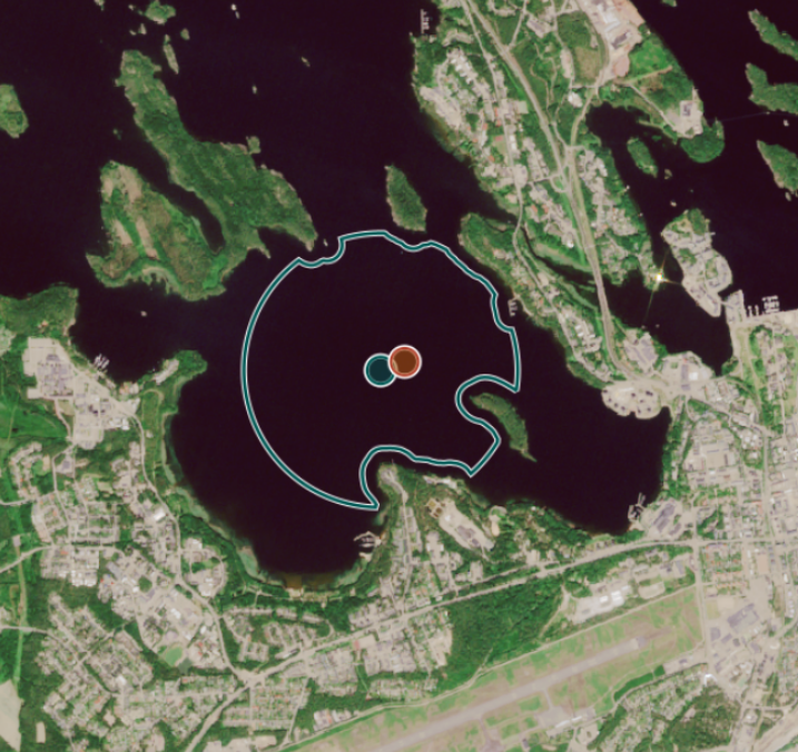
The panel on the left allows you to select datasets for viewing. Relevant materials include Reference stations under Additional GIS data and Station sites and Lake Pien-Saimaa automated observations under Timeseries.
You can use this Example link to open Tarkka with these datasets preselected (change the language to EN from the upper right corner or Tarkka+). You should now see station icons on the map:
This project has received funding from the European Union’s Horizon 2020 Research and Innovation Action programme under Grant Agreement No 101004157
![]()
![]()