Air quality (CAMS)
Copernicus Atmosphereic Monitoring service (CAMS)
Copernicus Atmosphere Monitoring Service (CAMS) provides consistent and quality-controlled information related to air pollution and health, solar energy, greenhouse gases and climate forcing, everywhere in the world.
CAMS is one of six services that form Copernicus, the European Union’s Earth observation programme which looks at our planet and its environment for the ultimate benefit of all European citizens. Copernicus offers information services based on satellite Earth observation, in situ (non-satellite) data and modelling.
CAMS is implemented by the European Centre for Medium-Range Weather Forecasts (ECMWF) on behalf of the European Commission. ECMWF is an independent intergovernmental organisation supported by 35 states. It is both a research institute and a 24/7 operational service, producing and disseminating numerical weather predictions to its member states.
To provide and further develop the CAMS portfolio, ECMWF works with many service providers around Europe. CAMS also coordinates the Copernicus Health Hub on behalf of the Copernicus Programme and its Services.
To acquire all the observations that are needed to produce the CAMS services, ECMWF collaborates with the European Space Agency (ESA) and the European Organisation for the Exploitation of Meteorological Satellites (EUMETSAT) as well as many other organisations providing satellite and in-situ observations.
CAMS builds on many years of European research and development, and on existing European and national capacities, experience and know-how. The current portfolio of mature operational products was designed in close consultation with the (potential) users and developed through a series of EU-funded precursor projects starting in 2005.
CAMS has been fully operational since 1 July 2015. The first phase ran until the end of 2020, in alignment with the Multiannual Financial Framework (MFF) of the European Union. The second phase of Copernicus, included in the European Space Programme is ongoing until 2027 as envisaged by the new MFF.
CAMS Datasets
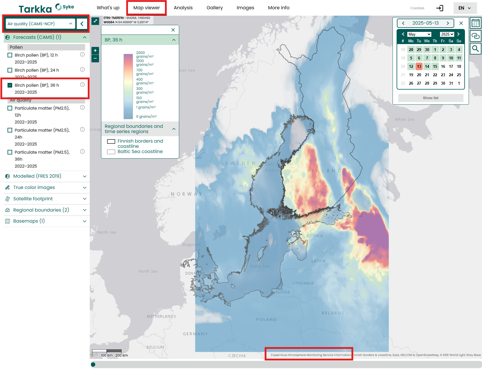
CAMS datasets can be accessed from Atmospehere Data Storage. The most prominent datasets for Finland’s use were identified and integrated into the Tarkka service. The datasets can be accessed from Tarkka’s Air Quality (CAMS) theme.. Detailed descriptions and links to selected datasets are included below.
European Air Quality Forecasts
CAMS produces specific daily air quality analyses and forecasts for the European domain at spatial resolution of 0.1° x 0.1° (at Finland’s location ~11km x 5km). The production is based on an ensemble of eleven air quality forecasting systems across Europe. Forecasts are produced and published once a day. Daily retrieved AQ forecasts at Tarkka visualize the surface level concentration of pollen or air quality variables at 9:00 UTC, approximately matching the Sentinel-2 and LC8/9 satellite overflight. Data is available from 11/2023 ->
Available parameters for pollens (grains/m3): alder pollen, birch pollen, and grass pollen as well as air quality variables (ug/m3): carbon monoxide, nitrogen dioxide, nitrogen monoxide, non methane vocs, ozone, particulate matter 2.5um (PM2.5), particulate matter 10um (PM10), and sulphur dioxide.
More information of original data European Air Quality Forecasts.
European Air Quality Reanalysis
CAMS European air quality reanalsis provides annual air quality reanalyses for Europe domain at spatial resolution of 0.1° x 0.1° (at Finland’s location ~11km x 5km). The reanalysis is based upon both unvalidated and validated observations, which are based on an ensemble of eleven air quality data assimilation systems across Europe. The reanalysis combines model data with observations provided by the European Environment Agency (EEA) into a complete and consistent dataset using various data assimilation techniques depending upon the air-quality forecasting system used. Additional sources of observations can complement the in-situ data assimilation, like satellite data.
Validated reanalysis datasets are retrieved and published to Tarkka annually as the data becomes available after ~2 year delay. Original data is provided as 1-hourly analyses, which are aggregated to daily medians (ug/m3) at surface level for the following variables: ammonia, carbon monoxide, nitrogen dioxide, nitrogen monoxide, non-methane volatile organic compunds, ozone, particulate matter 2.5um (PM2.5), particulate matter 10um (PM10), dust, and sulphur dioxide. The concentration values are at the surface-level height.
Global emission inventories
The Global emission inventory data contains gridded distributions of global anthropogenic and natural emissions. The dataset compiles inventories of emission data that serve as input to its own forecast models, but which can also be used by other atmospheric chemical transport models. These inventories are based on a combination of existing data sets and new information, describing anthropogenic emissions from fossil fuel use on land, shipping, and aviation, and natural emissions from vegetation, soil, the ocean and termites. The anthropogenic emissions on land are further separated in specific activity sectors (e.g., power generation, road traffic, industry). Because most inventory-based datasets are only available with a delay of several years, the CAMS emission inventories also extend these existing data sets forward in time by using the trends from the most recent available years, producing timely input data for real-time forecast models.
The Global emission inventories data published to Tarkka contains anthropogenic emissions combined as a sum of all sectors. The data is aggregated to monthly and yearly sums of total emissions per pixel (kg/pixel). The datasets include the variables black carbon, nitrogen oxides, non-methane volatile organic compunds, organic carbon, and sulphur dioxide. A supplementary dataset of Finnish emissions is also available at Tarkka for comparison.
Global biomass burning emissions based on fire radiative power (GFAS)
Emissions of atmospheric pollutants from biomass burning and vegetation fires are key drivers of the evolution of atmospheric composition, with a high degree of spatial and temporal variability, and an accurate representation of them in models is essential.
The CAMS Global Fire Assimilation System (GFAS) utilises satellite observations of fire radiative power to provide near-real-time information on the location, relative intensity and estimated emissions from biomass burning and vegetation fires.
GFAS data are also used in the CAMS global and regional reanalysis products, as well as the forecasts.
The data published to Tarkka currently contains data from the first version (1.2) of GFAS, which is provided for 1st of January 2003 to 31st December 2025. This data is based on the combination of fire radiative power observations from two MODIS instruments (EOS-Terra and EOS-Aqua). The observations are aggregated to monthly and yearly sums of total burning emissions per pixel (kg/pixel) for wildfire fluxes of black carbon and particulate matter.
Global atmospheric composition forecasts
CAMS produces global forecasts for atmospheric composition twice a day, that consist of more than 50 chemical species and different types of aerosols.
The initial conditions of each forecast are obtained by combining a previous forecast with current satellite observations through a process called data assimilation. This best estimate of the state of the atmosphere at the initial forecast time step, called the analysis, provides a globally complete and consistent dataset allowing for estimates at locations where observation data coverage is low or for atmospheric pollutants for which no direct observations are available.
The forecast itself uses a model of the atmosphere based on the laws of physics and chemistry to determine the evolution of the concentrations of all species over time for the next five days. Apart from the required initial state, it also uses inventory-based or observation-based emission estimates as a boundary condition at the surface.
Syke publishes the latest global atmospheric composition forecast daily, with 1-day delay. The forecasts presents AOD at 550nm of black carbon, dust, ammonium, nitrate, organic matter, sea salt, and sulphates as well as total AOD at 469nm, 550nm, 670nm, 865nm, and 1240nm at 12:00 Finnish Local Time.
Global reanalysis (EAC4)
<!– ### European air quality forecasts optimised at observation sites